Cape Disappointment was named by mistake. In 1788, a british fur trader named John Meares had heard about the confluence of a great river with the Pacific ocean and set out to establish a trading post at its mouth. But when he arrived, he could not navigate all of the sandbars and shallows and thus concluded that this was not the great river mouth that he had set out to find. He dubbed the land Cape Disappointment. In 1805, the Lewis and Clark Expedition arrived here. Julia and Kellan came back with this information after visiting the Lewis and Clark Interpretive Center that occupies a modern space on the bluff overlooking the Columbia River and the Pacific.

Your mission: the Pacific Ocean.
As river mouths go, Cape Disappointment has quite a bit of elevation, rising from sea level to more than 300 feet rather abruptly. I know this from studying the Tsunami Evacuation Chart that is posted outside of the wash house. Ever since a geography class in college, I have been interested in tsunamis. Living in Vermont, I have had no practical exposure to the actual threat of a tsunami. However, just being aware that they can occur seemed to put me ahead of a large portion of the population for many years. Recently, an article was published in The New Yorker that stimulated conversation and elevated fears about a tsunami threat. Kathryn Schulz wrote a well-researched piece (that is really worth reading) about the potential for a huge tsunami to inundate the Washington and Oregon coastal areas. The article pointed out that many areas along the coast do not have a tsunami evacuation plan, and even if they did, due to inadequate insfrastructure or geographical constraints, there would not be enough time to evacuate during the worst case scenario, which scientists predict is likely to occur within the next 50 years.

The information is right there. I wonder how many people have taken the time to read it?
I felt reassured by two facts that I read on the bulletin board and reconciled against what I already know: 1.) the park has a tsunami evacuation plan and a warning system that it tests every week, and 2.) under worst case conditions, as predicted by scientists, 300 feet above sea level should be an adequate evacuation height. Granted, it would not be an ideal situation and it would come with all sorts of complications, but I felt slightly reassured to know that within 1/4 mile, we could be breathing heavily atop ground high enough to withstand most tsunamis.
In the meantime, we spent a lot of time today enjoying everything that sea level has to offer. The kids found two old pieces of driftwood and made a see-saw that kept them entertained for a while. They buried each other so deeply in the fine sand that they will likely be finding grains on their pillows, in their sleeping bags, in their socks, and between their sheets for months to come. Feeling inspired from their time in the Lewis and Clark center, they also carved some rudimentary dugout canoes from small sticks and gave them a proper sea-test in the shore break. One boat made it home, the other was lost at sea.

We spend the afternoon on "Waikiki Beach", on the Columbia River side of the cape.

The black volcanic sand is an irresistable canvas.

Julia is not in this photo, but I can assure you that Kellan did not bury himself.
Speaking of lost at sea, in addition to the fire ban in Washington, there is a Japan Tsunami Debris alert in effect along the coast. The tragic earthquake and tsunami that struck Japan on March 11, 2011 and claimed 16,000 lives swept about 5 million tons of debris into the Pacific Ocean. Apparently, 30% of this debris was set afloat in the North Pacific and items have been arriving on northwestern US beaches. Looking out to the sea, it’s hard to believe that items from that natural disaster could be making landfall here after so many years. Just the thought of it makes you look at each piece of driftwood differently.

The profile of this rafter tail and the twisted iron nail are suggestive of Japanese architecture. This piece of wood could have traveled thousands of miles, or just 10.
The ocean will always remind you of its power. The driftwood here is impressive, both in scale and configuration. It’s clear that some strong storms have been at work out in this ocean. We briefly considered our own significance, or lack thereof, while sitting on the beach this evening enjoying the camper’s version of happy hour (chatting with new friends, enjoying a bottle of wine and trying to keep the sand off of the cheese.) In front of us, the sea appeared relatively calm and the sun warmed us until it disappeared behind the marine layer of moisture that makes seeing an actual sunset here a rare occurrence. Whatever was going to happen out there was beyond our current scope of vision.
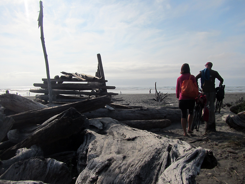
Walking out to the beach to enjoy the evening sun and a visit with new friends, Rob and Patty, who are from Eugene, OR.
I’m finishing up this post with the white noise of the ocean behind me. It is a sound that I have always found soothing and one that promises a solid sleep. We’ll crawl into the tent tonight to spend our last night at our turnaround point for the trip. Tomorrow we will follow the Columbia River upstream through Portland and finish our day in one of my favorite places in Oregon: Hood River.